Southern Ecuador
Solo, independent, self-guided birding trip, the closest I've come to fulfilling my travel philosophy.
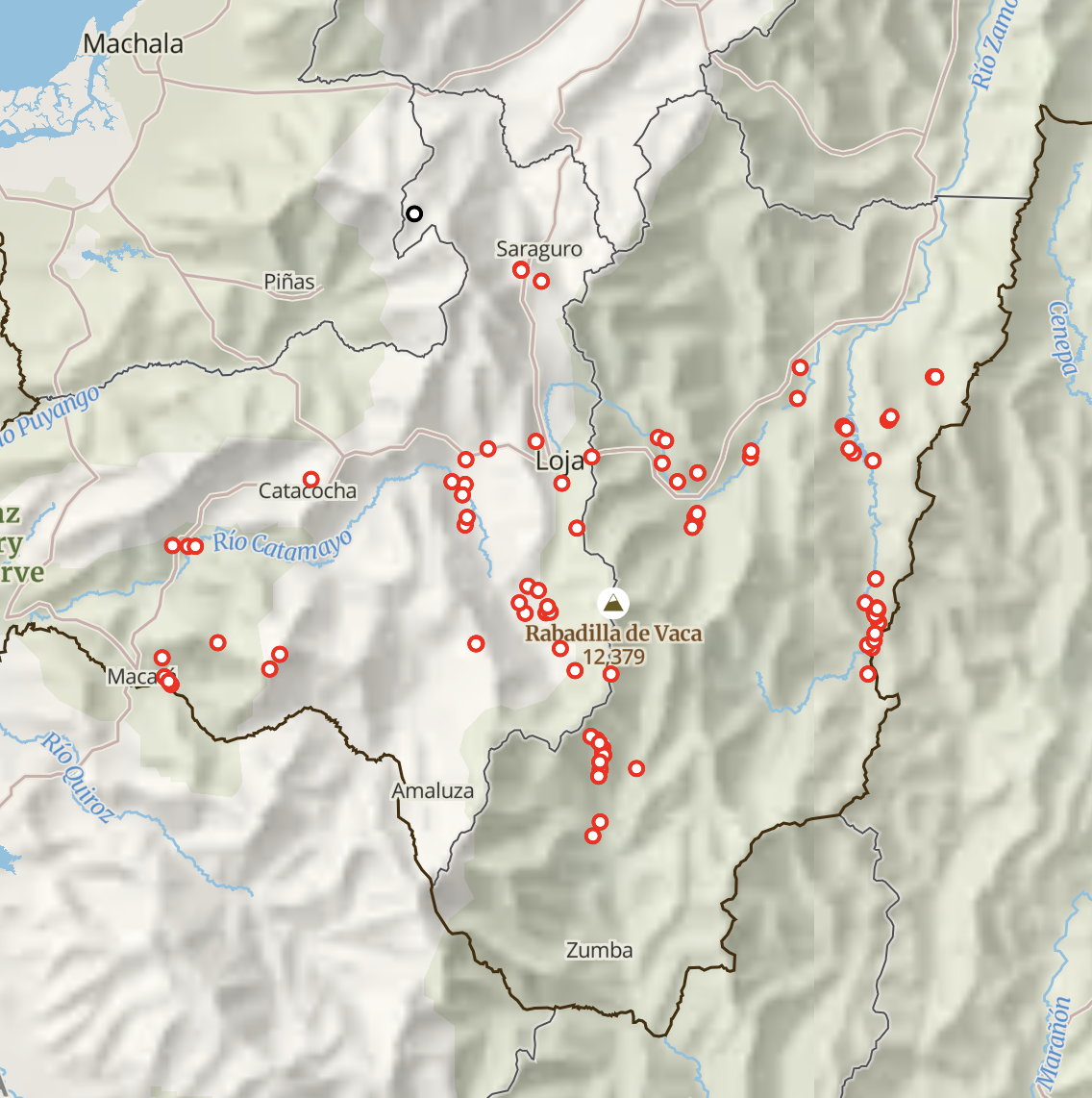
Intended as a 10-day trip around the Andes of southern Ecuador, including both cloud forest and foothills, along with a one-day stopover in Panama on the way.
Unfortunately, after only three days of birding in the Ecuadorean cloud forest, heavy rains ensued. Coming at the end of an already-extreme rainy season, those rains triggered severe flooding in the foothills, along with a multitude of landslides. I was completely unable to reach my intended destination in the foothills, and after further evaluating the developing situation, decided to evacuate and return to Loja. As the heavy rains continued, and with access to the foothills in the coming days becoming uncertain, I decided to cut the trip short and return home early.
As I was unable to visit several of the key sites that I was most excited about (Cabañas Yankuam area, Zamora area), and already have all of the logistics and planning done, it would be relatively straightforward for me to return someday, to complete what I had originally intended. But I will have to avoid March-May and the end of the rainy season!
Itinerary
- 4 May 2025 - direct flight from RDU to Panama City, Panama. Taxi to hotel in Via Argentina neighborhood.
- 5 May 2025 - Walk to Parque Andrés Bello. Uber to Parque Natural Metropolitano, spent many hours walking all of the trails throughout the park. Uber to Via Argentina neighborhood for lunch/beers, walking around city. Subway(!) across city to airport. Walk to hotel.
- 6 May 2025 - Shuttle to airport. Flight to Quito. Flight to Loja. Pickup rental car, drive to hotel in Catamayo. Dinner, look for shop selling local SIM card.
- 7 May 2025 - Morning birding various spots around Catamayo, dry Tumbesian scrub habitat. Drive to Malacatos, then Vilcabamba for lunch. Drive to Reserva Tapichalaca. Guided walk around trail loop.
- 8 May 2025 - Jocotoco Antpitta stakeout, failed. Guided walk around trail loop. Solo walk downhill along road, and back.
- 9 May 2025 - Solo walk uphill along road, and back. Afternoon drive to Valladolid, walk around town, invited to Fredy's garden.
- 10 May 2025 - Pouring rain. Drive to Vilcabamba, short hike at Cerro Mandango. Landslide blocked highway to Loja, so had to skip Cerro Toledo due to time crunch. Very roundabout drive back to Catamayo and then Loja, with short stops en route. Parque Colinar in Loja in the pouring rain. Hotel in Loja.
- 11 May 2025 - Still pouring rain. Drive towards Cabañas Yankuam, nervously eyeing raging flooded rivers. Just past Cumbaratza, hit stopped traffic. Looking ahead with binoculars, saw flood waters sweeping over the highway. Turned around, back to Zamora. Walk along Rio Bombuscaro, still pouring rain. Hotel in Zamora. Found Ecuadorean government flood monitoring dashboards, alarmed by trends, decided to evacuate back to Loja. Night in
Cabañas YankuamLoja. - 12 May 2025 -
Cabañas YankuamStill pouring rain, rivers still rising, made difficult decision to return home early. Drive back to Catamayo, flight to Quito, then back home. - 13 May 2025 -
Cabañas Yankuam - 14 May 2025 -
Cabañas Yankuam, Zamora - 15 May 2025 -
Zamora - 16 May 2025 -
Zamora, Loja, flight to Quito, return home
Logistics
Flights
Panama stopover was cheap and convenient with Copa Airlines.
Chose to fly into Loja/Catamayo, on Aeroregional. Smooth experience with airline, including changing flights on the way back, through WhatsApp in Spanish. But note that I wasn't able to book tickets on my Mac, trying multiple browsers, website strangely only seemed to work on Windows.
Guayaquil is a popular option to fly into for southern Ecuador, as a larger airport and with great birds in the area, but is currently struggling with security issues, that I did not feel comfortable navigating solo.
Transport
Excellent experience with Laguna Rent-a-car, booked through WhatsApp, in Spanish. Roads were largely okay, many paved and wide, though often had to deal with only-partially-cleared landslides, and potholes. Navigated using offline OSM maps through Organic Maps app (would use CoMaps spinoff app now). Only questionable moment was on the route between Catamayo and Malacatos via El Tambo - most cars seemed to head down a road that was not shown on any of my maps at all. I trusted the route shown by my apps, which took me to an extremely muddy stretch, by far the sketchiest section that I drove on the trip, but I did make it through. On the return drive, I tried the un-shown road instead, and it turned out to be remarkably smooth and easy, despite being true terra incognito.
Lodging
- Hotel Ciudad de Catamayo - adequate room, friendly staff, but poor WiFi, few other options in town
- Casa Simpson at Reserva Tapichalaca - excellent but expensive, no other options nearby
Hostería Paraíso Vilcabamba- canceled due to long landslide detour needed- Sonesta Hotel Loja - cheaper options available, but still reasonable, had parking lot, and overall excellent
Cabañas Yankuam- could not visit due to flooding- Hotel Wampushkar Zamora - basic but clean and good, friendly staff, good WiFi
Communication
Local SIM card through Claro, bought at a pharmacy in Catamayo, worked great. Added more data and days at a Claro shop in Vilcabamba. Tried an eSim through Airalo, but as reported earlier by Vandermeulen, it doesn't seem to work in southern Ecuador for some reason. It did work in the Quito airport.
My beginner-to-low-intermediate Spanish was adequate for getting things done. Google Translate with offline pack download an essential tool for quick preparation for conversations. Only met one or two English speakers, both at hotels, everything else was in Spanish.
Timing
Rainy season is roughly early January through early May. Bird activity seems to be highest at the very beginning of the rainy season, so December/January seem to be a popular times. Though my 2025 trip was at the tail end of the rainy season, which meant better weather, it did mean higher risks of landslides and floods due to saturated ground and high rivers.
Other branches considered
- Paquisha, Reserva Zarza - would require night in small hotel in Paquisha or Los Encuentros, or camping. Very interesting and under-explored area. Not enough time to fit in, and ultimately couldn't access due to floods anyway.
- Saraguro area - Red-faced Parrot, Chestnut-bellied Cotinga, Crescent-faced Antpitta, etc. Scrapped due to long drive, somewhat low diversity, town looked depressed with somewhat exploitative tourism. Did seriously consider pivoting to visiting after all, once foothills became inaccessible, but had too many concerns about landslide risks, and would've lost another day to rain anyway, didn't feel worthwhile.
- Cerro de Arcos for Blue-throated Hillstar - same issues as Saraguro area, but even more pronounced - extremely long drive on poor roads, additional landslide risk, likely cold and rainy. Would be easier with travel partners to help with driving load.
- Tumbes - interesting habitat and many endemics. But very long drive with few/no interesting stops en route. Decided that getting a taste around Catamayo and Vilcabamba was sufficient for now.